MIME search
Jump to navigation
Jump to search
This page enables the filtering of files for their MIME type.
Input: contenttype/subtype or contenttype/*, e.g. image/jpeg.
Showing below up to 50 results in range #7,551 to #7,600.
- (download) Flood of 1936 See the Coal Tipple and Roundhouse in the background.jpg . . 567 × 960 . . 43 KB . . HistoryCommission2 . . 15:07, 24 October 2019
- (download) Flood of 1936 The Gross Store.jpg . . 2,048 × 1,224 . . 227 KB . . HistoryCommission2 . . 13:45, 24 October 2019
- (download) Flood of 1936 The Roundhouse from another angle.jpg . . 720 × 413 . . 43 KB . . HistoryCommission2 . . 15:01, 24 October 2019
- (download) Flood of 1936 The Roundhouse in the flood.jpg . . 423 × 720 . . 37 KB . . HistoryCommission2 . . 15:02, 24 October 2019
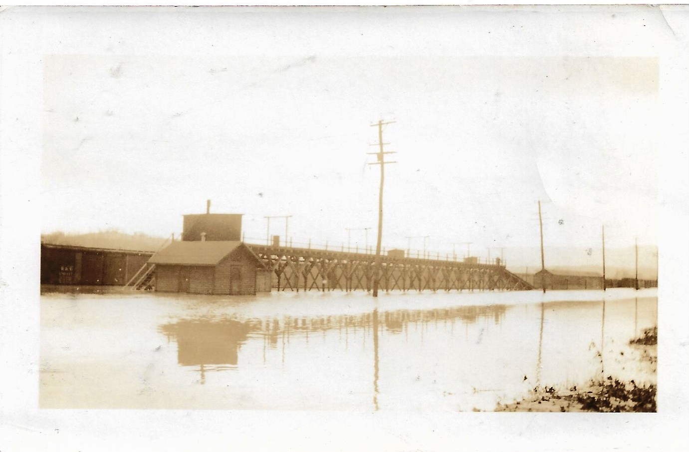
- (download) Flood of 1936 Train Station.jpg . . 1,381 × 908 . . 177 KB . . HistoryCommission2 . . 18:01, 18 August 2020
- (download) Flood of 1936 Upper Hump.jpg . . 1,381 × 905 . . 172 KB . . HistoryCommission2 . . 18:02, 18 August 2020
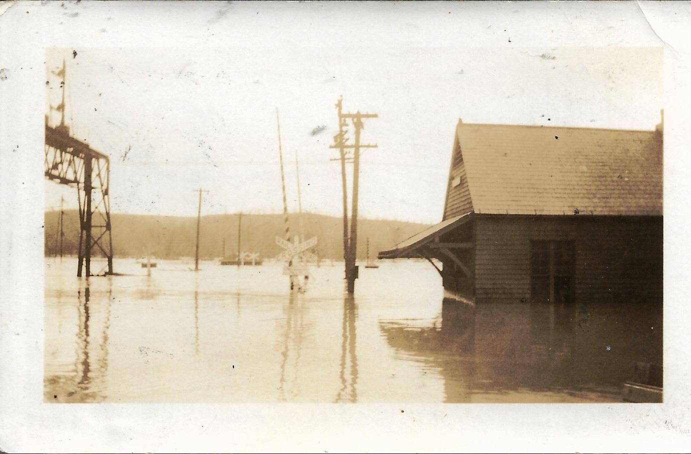
- (download) Flood of 1936 at the South Maple Avenue crossing..jpg . . 2,048 × 1,224 . . 242 KB . . HistoryCommission2 . . 13:47, 24 October 2019
- (download) Flood of 1936 back porch of the B&O YMCA.jpg . . 2,048 × 1,224 . . 169 KB . . HistoryCommission2 . . 14:41, 24 October 2019
- (download) Flood of 1936 between the box cars.jpg . . 2,048 × 1,224 . . 256 KB . . HistoryCommission2 . . 14:42, 24 October 2019
- (download) Flood of 1936 from South Maple Avenue.jpg . . 2,048 × 1,224 . . 480 KB . . HistoryCommission2 . . 15:05, 24 October 2019
- (download) Flood of 1936 from the YMCA.jpg . . 2,048 × 1,224 . . 267 KB . . HistoryCommission2 . . 14:31, 24 October 2019
- (download) Flood of 1936 in Point of Rock. Photo courtesy of Phil Lowery.jpg . . 604 × 367 . . 42 KB . . HistoryCommission2 . . 15:13, 24 October 2019
- (download) Flood of 1936 in Point of Rocks.jpg . . 604 × 367 . . 50 KB . . HistoryCommission2 . . 15:10, 24 October 2019
- (download) Flood of 1936 men in a rowboat.jpg . . 2,048 × 1,162 . . 572 KB . . HistoryCommission2 . . 13:42, 24 October 2019
- (download) Flood of 1936 on S. Maple Avenue with the train station to the right.jpg . . 495 × 881 . . 34 KB . . HistoryCommission2 . . 14:46, 24 October 2019
- (download) Flood of 1936 scene at Sandy Hook..jpg . . 720 × 429 . . 86 KB . . HistoryCommission2 . . 15:43, 24 October 2019
- (download) Flood of 1936 shows the flooded Brunswick railyard.jpg . . 604 × 466 . . 35 KB . . HistoryCommission2 . . 14:39, 24 October 2019
- (download) Flood of 1936 the WB Tower.jpg . . 594 × 960 . . 73 KB . . HistoryCommission2 . . 15:00, 24 October 2019
- (download) Flood of 1936 view of the eastbound station,.jpg . . 2,048 × 1,175 . . 583 KB . . HistoryCommission2 . . 13:51, 24 October 2019
- (download) Flood of 1942 Old Brunswick Mill submerged by flood waters. This photo was taken on October 16, 1942..jpg . . 1,658 × 922 . . 346 KB . . HistoryCommission2 . . 15:46, 24 October 2019
- (download) Flood of 1942 looking toward the Eastbound train station and the mill.jpg . . 1,644 × 954 . . 265 KB . . HistoryCommission2 . . 15:47, 24 October 2019
- (download) Flood of 1942 undid much of the initial canal restoration work from the previous flood in 1936..jpg . . 720 × 960 . . 83 KB . . HistoryCommission2 . . 15:53, 24 October 2019
- (download) Flood of 1972, Roundhouse in the background.jpg . . 1,442 × 1,081 . . 135 KB . . HistoryCommission2 . . 15:58, 24 October 2019
- (download) Flood of 1972 - Hurricane Agnes.jpg . . 604 × 403 . . 41 KB . . HistoryCommission2 . . 15:55, 24 October 2019
- (download) Flood of 1972 Hurricane Agnes flood in the Brunswick railroad yard..jpg . . 1,436 × 1,299 . . 202 KB . . HistoryCommission2 . . 16:02, 24 October 2019
- (download) Flood of 1972 The Monocacy river at its highest flood stage.jpg . . 617 × 602 . . 51 KB . . HistoryCommission2 . . 16:12, 24 October 2019
- (download) Flood of 1972 The Point of Rocks railroad tunnel.jpg . . 960 × 944 . . 104 KB . . HistoryCommission2 . . 16:08, 24 October 2019
- (download) Flood of 1972 after Hurrican Agnes.jpg . . 912 × 906 . . 75 KB . . HistoryCommission2 . . 16:04, 24 October 2019
- (download) Flood of 1972 men rowing a boat through Point of Rocks.jpg . . 960 × 957 . . 91 KB . . HistoryCommission2 . . 16:09, 24 October 2019
- (download) Flood of 1985 in Point of Rocks, November, 1985..jpg . . 1,242 × 970 . . 107 KB . . HistoryCommission2 . . 16:43, 24 October 2019
- (download) Flood of 1985 on the Potomac River. Photo taken from the Bridge (1).jpg . . 719 × 564 . . 71 KB . . HistoryCommission2 . . 16:49, 24 October 2019
- (download) Flood of 1985 on the Potomac River. Photo taken from the Bridge (2).jpg . . 720 × 595 . . 70 KB . . HistoryCommission2 . . 16:50, 24 October 2019
- (download) Flood of 1985 on the Potomac River. Photo taken from the Bridge (3).jpg . . 719 × 578 . . 75 KB . . HistoryCommission2 . . 16:50, 24 October 2019
- (download) Flood of 1985 on the Potomac River. Photo taken from the Bridge (4).jpg . . 720 × 554 . . 75 KB . . HistoryCommission2 . . 16:51, 24 October 2019
- (download) Flood of 1985 on the Potomac River.jpg . . 719 × 566 . . 62 KB . . HistoryCommission2 . . 16:44, 24 October 2019
- (download) Flood of 2010 Between Sandy Hook and Hoffmaster Rd. The river is almost on the tow path. Picture from a distanc.jpg . . 720 × 540 . . 76 KB . . HistoryCommission2 . . 17:01, 24 October 2019
- (download) Flood of 2010 Between Sandy Hook and Hoffmaster Rd.jpg . . 540 × 720 . . 60 KB . . HistoryCommission2 . . 17:00, 24 October 2019
- (download) Flood of 2010 Canal, tow path and Potomac River west of Sandy Hook, across the river from Harper's Ferry..jpg . . 720 × 540 . . 116 KB . . HistoryCommission2 . . 17:07, 24 October 2019
- (download) Flood of 2010 East side of Bridge at the Brunswick boat ramp.jpg . . 720 × 478 . . 70 KB . . HistoryCommission2 . . 17:08, 24 October 2019
- (download) Flood of 2010 East side of Bridge looking down at Brunswick boat ramp and submerged bathroom..jpg . . 720 × 540 . . 80 KB . . HistoryCommission2 . . 17:10, 24 October 2019
- (download) Flood of 2010 East side of Bridge looking down into the canal, tow path and Potomac River.jpg . . 720 × 540 . . 88 KB . . HistoryCommission2 . . 17:21, 24 October 2019
- (download) Flood of 2010 Entrance to the Brunswick boat ramp.jpg . . 720 × 478 . . 95 KB . . HistoryCommission2 . . 16:56, 24 October 2019
- (download) Flood of 2010 Looking west towards West Virginia from the Brunswick Bridge..jpg . . 720 × 540 . . 51 KB . . HistoryCommission2 . . 16:53, 24 October 2019
- (download) Flood of 2010 Point of Rocks.jpg . . 720 × 540 . . 70 KB . . HistoryCommission2 . . 16:58, 24 October 2019
- (download) Flood of 2010 Point of Rocks Courtesy of Lila Wenner.jpg . . 720 × 540 . . 58 KB . . HistoryCommission2 . . 16:59, 24 October 2019
- (download) Flood of 2010 This is just east of the Brunswick boat landing.jpg . . 720 × 478 . . 124 KB . . HistoryCommission2 . . 16:57, 24 October 2019
- (download) Flood of 2010 Tow path West of Sandy Hook.jpg . . 720 × 540 . . 122 KB . . HistoryCommission2 . . 17:06, 24 October 2019
- (download) Flood of 2010 West side of the bridge looking back towards Brunswick.jpg . . 720 × 540 . . 84 KB . . HistoryCommission2 . . 16:55, 24 October 2019
- (download) Flood of 2010 in Sandy Hook.jpg . . 720 × 540 . . 115 KB . . HistoryCommission2 . . 17:04, 24 October 2019
- (download) Flood of 2018 Flooding St Mark's Rd.jpg . . 714 × 960 . . 96 KB . . HistoryCommission2 . . 17:31, 24 October 2019
.jpg)
.jpg)
.jpg)
.jpg)